Jim
Hain
Associated Scientists at Woods Hole, Woods Hole, Massachusetts
jhain@earthlink.net
Jim Hain received his Ph.D. in biological oceanography from the University of Rhode Island in 1975. He has conducted research from Newfoundland to South America, with emphasis on the U.S. outer continental shelf and coastal habitats of endangered marine mammals. One of his areas of expertise is in aerial surveys, with experience in fixed-wing aircraft, helicopters, blimps, and most recently, with aerostats. He routinely uses statistical analyses and geographic information system (GIS) methods. While with Associated Scientists, Jim has been awarded grants or contracts from the U.S. Army Corps of Engineers, Marine Mammal Commission, Minerals Management Service, National Science Foundation, and the Office of Naval Research. He is a member of the Society for Marine Mammalogy, Senior Member of the American Institute of Aeronautics and Astronautics, and serves as Editor of Right Whale News. In October 1997, he received a Coastal America Award for his research relating to the mitigation of ship strikes on right whales on their wintering calving grounds.

PROJECT DESCRIPTION
Cetacean observations from an aerostat: a developing capability
Lei Harris and Jim Hain
In preparation for a field
investigation of disturbance to right whales due to the presence of vessels, a
14-day pilot study was conducted in August 2002 to test the study design and
equipment. A remotely operated camera
was mounted below a 1500 cubic foot aerostat to passively record right whale
behavior in the Bay of Fundy. The
advantages of this overhead video system included: real time information,
increased accuracy of behavioral data, a unique perspective, and the ability to
locate a whale up to 5 meters below the surface. Due to the remote
characteristics of the aerostat, close vessel approaches were not required.
Preliminary data for the behavioral study were collected. The methodology also proved useful in the
assessment of a whale prior to a disentanglement effort. Video-frame grabs were also used for
photo-identification and documentation of scars and marks. Our experiences in
the pilot study will allow us to make refinements prior to 2003 field season.
__________
Abstract from the North Atlantic Right Whale Consortium
meeting, New Bedford, Massachusetts, 29-30 October 2002
PROJECT DESCRIPTION
Shore-based observations of right whales: Science and stewardship
Jim Hain
A collaboration between
twoorganizations (Associated Scientists and the Marine
Resources Council) is aimed at improving methods and increasing the value of
right whale sightings data contributed by a volunteer sighting network (VSN) in
coastal waters of NE Florida. In its
ninth year, the VSN consisted of four linked components: 1) training,
education, and outreach, 2) opportunistic sightings, 3) dedicated watches, and
4) sighting responses. In the 2008-2009
season, there were 71 sighting reports. Of these, 44 were verified right whales, of which most were photographed
and photo-identified. The research included
'follows' of right whales for behavioral characterization, with an average of 5
1/2 hrs per follow. The shore-based
sightings were supplemented by observations from boats and
aircraft. With the increased data
quality, the VSN provides a valuable complement to the aerial surveys,
geographically and temporally. An
important dimension is the direct and effective involvement of local citizens
(including young people). The efforts
of 1-2 scientists are magnified, sighting effort is increased, and awareness
and stewardship enhanced. Multiple
linked and diverse approaches, as well as broad collaboration, are essential to
the successful study and monitoring of right whales and their habitat in SE
U.S. coastal waters.
__________
Summary from Project Report, 5 October 2009
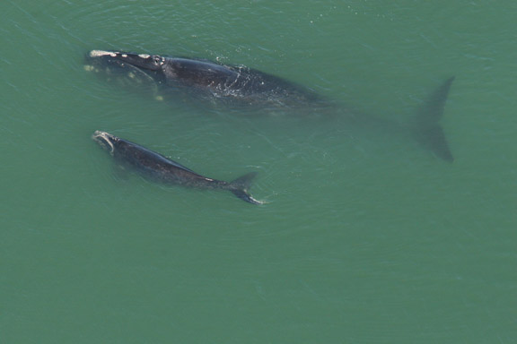
A mother/calf right whale sighted near
Matanzas Inlet, Florida, 15 February 2006.
(Photo: J.D. Hampp)
Home Organizational Description Investigators & Projects Books, Pubs & Reports Woods Hole Directory Contact Us